
LAND SURVEYING IN ALABAMA
AKA “THE FAIRCLOTH NOTES”
By: J. M. FAIRCLOTH
PREFACE BY J. KEITH MAXWELL, PLS, PE
I’ve always been intrigued by the history of land surveying. I grew up at the foot of Cheaha Mountain in rural Talladega County, Alabama. From the age of 14 I helped my Dad, Johnny Earl Maxwell, PLS, with boundary surveys on and around the mountain. In many places we surveyed along the National Forest or State Park boundaries and we would find all kinds of historical artifacts, in addition to the occasional old whiskey still. When we would find an old Section corner of a “lighter knot” it made me think of the surveyors who went before us, who set these monuments.
I took a keen interest in surveying because of the mathematics of it, because it was done outside and often in the woods, where I liked to spend time as a teenager. It was certainly much more fun than bailing hay.
My brother Joel E. Maxwell worked with us a lot of the times as he was only 2 years younger than me. He flew the coop as soon as he was 18 and went to work for Delta Airlines. My youngest brother Wm Allen Maxwell, PLS also helped Dad and later came to work for me for a number of years before getting his license. After that, he moved back home to work with Dad. He passed away unexpectedly in February 2014 having enjoyed living there in Talladega County and surveying that whole time. He loved the field part of the work much more than the office work.
I’m in the office mostly today, but still think fondly of all of the adventures and experiences in land surveying over the years. I think of the old surveyors I’ve learned from, many gone on now, Boyd Washburn, Chester A Smith, William “Bill” Camp, and Larry Speaks. I also learned from surveyors while in the Army, while working my way through college (Zack Sprayberry and Jim McCrory), while working for the Alabama Highway Department, now Alabama D.O.T., (Jerry Burger, Joe Jones, Mac Rotten, Rex Bush, and Willie Mac Carraway) and from fellow surveyors I’ve worked with over the years (my friend Glen Tanner, and T. Richard Fuller.) There are also numerous young men and women that have worked for me over the years who have gone on to be licensed land surveyors and engineers that I’ve enjoyed having the opportunity to work with and help along the way.
I want to continue to encourage new surveyors and remind them of the history. In that light I wanted to produce this document so that it can be preserved, and be searchable. I used to have an old copy from a mimeograph machine in my files, and probably still do if I could find it, but I found this one where we find everything these days, on the internet and have copied it and done only a little reformatting. I hope you enjoy having it in your files.
James Manning Faircloth, was a professor of civil engineering at The University of Alabama during the years 1928 through 1964. Faircloth also wrote Elementary Plane Surveying for engineers “who do not expect to practice surveying.” The Faircloth Notes have been compiled and published in 1992 by CED Technical Services along with other of his notes and documents.. This document uses only those Notes as supplied by the Alabama Board of Licensure.
I have placed a few notes in { } to aid in understanding only.
PREFACE
There are numerous treatises on land surveying available to the engineer or surveyor today. The legal, theoretical, and practical aspects of general land surveying are all easily available in great detail. However, there is no writing known to the author which deals specifically with surveying in Alabama or which touches in any appreciable degree upon the problems encountered in Alabama. This manual is not intended to cover the general type of material easily available in the usual surveying text, the manual of the U.S. Land Office or the many other references on surveying; but rather is intended to supplement these writings with information specific to Alabama.
The author recognizes a growing need in Alabama for some source of information for the young land surveyor. Few colleges continue to include courses in land surveying in their required curricula, and few references are made to land surveying in the engineering courses on surveying. The increasing values of real property creates a growing public demand for competent land surveyors. The engineering graduate has little training or background for land surveying and has no avenue available for obtaining this information other than through practical experience. One of the purposes of this manual is to provide some of this information and to present some of the problems to be encountered in Alabama.
The Board of Licensure for Professional Engineers and Land Surveyors in Alabama is faced with the problem of a large public demand for land surveyors that cannot be filled on the one hand, and the maintenance of high professional standards with adequate means for training land surveyors on the other. It is the hope of the author that this manual may improve this situation to some extent.
The author makes no claim to originality for much information contained herein and which has commonly been included in many books and manuals on surveying over a period of many years. Much of the information used herein comes from practicing surveyors, most of whom are possessors of a vast wealth of land surveying facts and techniques which cannot easily be transmitted to others. Acknowledgment is made to governmental agencies and other sources for much of the material included.
 The author especially wishes to acknowledge the valuable contributions over many years of the late E. E. Todd
*LeMaitre
Clark, on Surveying and Boundaries – (Bobbs-Merrill Company)
Skelton, Boundaries and Adjacent Properties – (Bobbs-Merrill Company)
INTRODUCTION
The land surveyor is called upon to make two types of surveys; Original Surveys and Resurveys.
Original Surveys involve the virginal marking out on the ground of boundaries or parcels of land, however great or small; and the establishment of monuments, corners, lines, and divisions of land for the first time.
There are two general types of original surveys.
In one type of original survey the authorized surveyor establishes, or puts in and references, corners; and he makes all necessary measurements for marking and describing the lines between corners, for record.
In the other type of original survey the surveyor is called upon to determine the area of land defined by natural or artificial boundaries and possibly to divide this area for the first time.
Some original land surveys in the United States consist of:
(a) The surveys of all lands not granted by original states of the Union to the federal government.
(b) The rectangular surveys of public lands of the United States known as the government surveys.
(c) Subdivision of sections in Alabama, not previously subdivided.
(d) Surveys for subdivisions such as city lots.
Resurveys of lands involve the retracement of lines or boundaries which have already been established or marked upon the ground by authorized persons at some prior time. In most instances in the United States today the surveyor is called upon to retrace an original land survey or to make a survey.
Resurveys of land in the United States usually consist of:
(a) Finding the corner posts or monuments on a tract of land.
(b) Relocating and reestablishing lost corners.
(c) Retracing old boundary lines.
(d) Finding, laying out, designating fixed areas.
(e) Subdividing sections which have been previously subdivided, etc.
Quite often the surveyor loses sight of the main objectives of the two types of surveys. While the original survey, in the main, is an attempt to mark, bound, or lay out an area for the first time, the resurvey is almost solely for the purpose of retracing or again locating the very same original lines, corners or areas. The resurvey involves very little original work, if any, but does involve the execution of a great deal of judgement and intelligent reasoning in attempting to retrace the exact lines and areas of the original or old survey. In many cases the results of the resurvey hinge upon very thin threads of evidence of the old survey, interpreted through a thorough knowledge of surveying methods and through laws relating to surveys and surveyors.
In an original survey it is the function of the surveyor to make an accurate survey, establish permanent monuments and true markings, and make a clear and accurate record of his work in the form of field notes and a plot. {plat} The methods used and the accuracy demanded in this type of survey depend upon the use for which the survey is intended. Emphasis is placed on this type of survey in the usual course in surveying taught in schools today.
In a resurvey it is the function of the surveyor to find where the monuments, courses, lines and boundaries originally were, and not where they ought to have been. Failing in this it is his business to re-establish them as nearly as possible in the place they were originally placed.
As a general rule any deviation from the exact original survey is untenable and illegal. In most cases such a deviation can cause only confusion and difficulty, and frequently can cause great material loss or damage to land owners. Too much emphasis cannot be placed upon correctly locating and retracing the exact lines or boundaries of the original survey. The correctness or the accuracy of the original survey is seldom involved or is rarely of much concern to the person making the resurvey. Usually if the first survey was improperly executed the resurvey must still retrace the same lines and encompass the same areas as the original survey.
No re-established point or line, no matter how carefully located, will have the same weight as the original point or line – if the latter can be found.
In making resurveys the surveyor has no official power to decide disputed points, or to locate new points. He can act only as an expert witness. If the interested parties do not agree to accept his decision, the questions must be settled in the courts.
In the successful execution of a land survey, it is necessary that a surveyor know and understand both types of surveys. Although a land surveyor may not usually be called upon to make original surveys, he cannot intelligently make an accurate resurvey without a detailed knowledge of the conditions and limitations of the original survey. Quite often a knowledge of the correct methods and actual procedures of making original surveys makes it possible for the surveyor to intelligently and correctly interpret the actions of the original surveyor and therefore accurately retrace the original survey. In making resurveys therefore it is very desirable for the land surveyor to know history and development of land surveying in this country.
DEVELOPMENT OF THE U.S. SYSTEM FOR LAND SURVEYS
 The original thirteen colonies of…
- New Hampshire;
- New York;
- Rhode Island and Providence Plantations;
- New Jersey;
- New Castle, Kent and Sussex on Delaware;
- Pennsylvania;
- Virginia;
- Maryland;
- Massachusetts Bay;
- Connecticut;
- South Carolina;
- North Carolina; and
- Georgia
…held lands under grants from Great Britain. There was little or no system for surveying these lands and land disputes were common. Ownership to much of these lands was disputed between colonies. In most of the above area comprising the present states of
- Maine,
- New Hampshire,
- Vermont,
- New York,
- Massachusetts,
- Connecticut,
- Rhode Island,
- New Jersey,
- Pennsylvania,
- Delaware,
- Maryland,
- Virginia,
- West Virginia,
- Kentucky,
- Tennessee,
- North Carolina,
- South Carolina, and
- Georgia;
…as well as the State of Texas, land holdings and land surveys by metes and bounds developed without a definite method of land surveying. In these states parcels of land are of irregular shape with little or no uniform pattern. Natural boundaries such a streams often determined the size and shape of a tract of land. Land descriptions in these areas usually consisted of bearings of directions and distances between irregularly place corners, with a calculated area of the usually irregularly shaped area.
The territory comprising the present states of Ohio, Indiana, Illinois, Michigan, Wisconsin, Tennessee, that part of Minnesota lying east of the Mississippi River, all of Alabama, and Mississippi lying north of the thirty-first parallel, was held by Massachusetts, Connecticut, New York, Virginia, North Carolina, South Carolina, and Georgia under grants from Great Britain. The territory described above was surrendered by the last seven named states to the general government of the Union, in pursuance of a resolution of the Congress of the Confederation passed October 10, 1780, and providing for the reception and care of ceded lands for disposition for the common benefit of the United States. This land was also a part of the concession from Great Britain under the definition treaty of 1783 and formed the nucleus of our public domain. In 1803, prior to the Louisiana purchase, this public domain amounted to about 405,000 square miles. Since 1803 and by 1867, the public lands had been increased by purchase and annexation to make more than 3,000,000 square miles. This area includes Florida, ceded by Spain in 1821. Immediately upon acquisition of even a portion of this public domain it became obvious that some uniform and orderly system of dividing, designating, and describing this land was essential for dependable record and distribution.
Congressional acts establishing and developing our present day “System of Public Land Surveys” followed. This system was not devised and passed at one time, but rather was developed over a period of time. Methods used in land surveys at certain times and places in the past, in accordance with the law at the time, will differ materially from surveys made in accordance with the law at a later date. The old surveys or methods established lines or boundaries which were and still are the legal and correct lines for that land, despite the fact that later or present legal methods of survey will give entirely different lines.
It is therefore obviously necessary that a land surveyor know the history of the development of land surveying laws so that he may know the correct procedure to use in resurveying or relocating points and lines.
SYSTEM OF PUBLIC LAND SURVEYS
After the United States was recognized by Britain as an independent nation, this government of the United States became custodian for the nation of all lands, called public lands, not owned or claimed by individuals. Almost immediately the Congress began making provision for an orderly disposition of these lands.
A committee was appointed by the Continental Congress to ascertain a mode of locating and disposing of public lands. In May, 1784, this committee reported or recommended an ordinance requiring lands to be divided into “hundreds” of ten geographical miles square, and these “hundred” into lots of one mile square and numbered from 1 to 100. These numbers were to commence in the north-western corner, continue from west to east and them from east to west.
The above ordinance was amended in April, 1785, to require surveyors to divide lands into townships of 7 miles square by lines running due north and south, and by other lines crossing these lines at right angles. The townships were to be subdivided into sections of 1 mile square of 640 acres each {80 chains x 80 chains = 6400 square chains}, by lines in the same direction as the external or township lines, and numbered from 1 to 49. These {are the} first records of the use of the terms “township” and “section” in connection with land surveys.
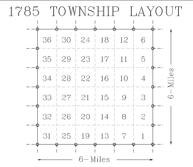
Figure 1. Subdivision of Township (6 mile square) in Ohio as provided in Act of Congress dated May, 1785. Townships were numbered South to North, Ranges were numbered East to West. Dotted section lines were not surveyed
In May, 1785, the “township” was changed from 7 miles square to 6 miles square, containing 36 sections of 1 mile square each. The first public land surveys were actually made under this ordinance. Under the direction of the geographer of the United States, townships six miles square were laid out in ranges extending northward from the Ohio River. The townships were numbered from south to north and the ranges from east to west. In these surveys only the exterior township lines were surveyed, but the sections of 1 mile square were marked off or drawn on the plots. Mile corners were established on the township lines. The sections were numbered from 1 to 36, commencing with 1 in the southeast corner of the township, and running from south to north in each tier to 36 in the northwest corner of the township.

Figure 2. Present Method of Numbering Sections as provided in Act of Congress dated May, 1796. Only half of section lines (alternate ones) were run as shown. Section corners were established as shown by circles. Dotted section lines were not surveyed.
An Act of Congress in May, 1796, provided for the appointment of a surveyor-general and directed the survey of lands northwest of the Ohio River and above the mouth of the Kentucky River. This law directed that one-half of the townships north-south and east-west parallel lines at end of every two miles and by establishing a corner on each of the lines at the end of every mile. The act further stipulated that the ratios be numbered by beginning with 1 in the northeast section and proceeding west and east alternately through the township until 36 has been reached in the southeast corner.
This method of numbering sections is still in use.
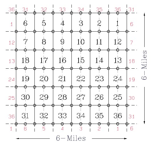
Figure 3. Subdivision of Townships as provided in Act of Congress dated May, 1800. Provided for half-sections of 320 acres each. Dotted lines were not surveyed. Established corners shown by circles.
In May, 1800, Congress passed an act requiring that townships west of the Muskingom be divided into quarter township, to be subdivided as nearly as possible into half sections of three hundred and twenty acres each, by running parallel lines through townships from east to west and from south to north, at the distance of one mile from each other. Corners were to be marked at the distance of each half-mile on lines running east to west, and at the distance of each mile on lines running from south to north. The interior lines of the township intersected by the Muskingom, and all townships lying east of that river which had not previously been actually subdivided into sections were to be surveyed or run and marked.
Another provision of the May, 1800, Act, which was not followed in Alabama, stated that in all cases where the exterior lines of the townships to be divided into sections or half sections shall exceed, or shall not extend, six miles, the excess or deficiency shall be specially noted and added to or deducted from the western and northern ranges of sections or half sections in such township, according to the error made in running lines from east to west or from south to north.
Only the more important congressional acts and those affecting land surveying in Alabama are included herein. All practicing land surveyors are advised to become familiar with the contents and dates of these acts so as to intelligently retrace a survey made around a certain date and according to the procedure at that time.
{The Act of February, 1805 instructed that the land be divided into quarter-sections which would add the half-mile points to be set on the north and south direction lines.}
U.S. SYSTEM OF RECTANGULAR SURVEYS
The development and the extension or the establishment of the rectangular system of public land surveys over the public domain in the United States has progressed as the need arose over the past 150 years and by steps gradually reached its present form.
At the present time the U.S. System of Rectangular Surveys is a very thoroughly and carefully developed procedure in all of its details. It consists principally of five parts:
(1) The initial point;
(2) Principal Meridian and Base Line;
(3) Guide Meridians and Standard Parallels;
(4) The formation of the primary unit of area, the township 6 miles square,
by lines parallel to Guide Meridians and Standard Parallels; and
(5) The subdivisions of townships into 36 sections each by parallel lines through the township.
All needed or necessary initial points have already been established in the United States Proper. These were usually established as beginning points where it became necessary for the administration of the disposal of public lands. It may still be necessary to establish initial points in Alaska or other possessions outside the United States Proper.
In establishing principal Meridians, base lines, standard parallels, and guide meridians the maximum allowable error between successive measurements are 14 links per 80 chains in distance and 0° 03′ 00″ in alignment.
In the U.S. System as constituted today a Principal Meridian is a true meridian or a line run from the initial monument either north or south or in both directions. In other words a line from the initial point toward the true north pole. Regular quarter-section and section corners are established along the Principal Meridian alternately at 40 chain intervals. Regular township corners are established on this meridian at intervals of 480 chains. Meander corners are established at the intersection of this meridian with any and all meanderable bodies of water.
A true meridian may be established with an ordinary engineer’s transit by observing the sun, Polaris, or some other heavenly body at a particular time, and then calculating the azimuth or the angle from this line to a true meridian, by use of easily available Ephemeras or set of astronomical tables. It is fairly simple procedure, by use of such tables, to establish a true meridian by observing Polaris.
From the initial point the Base Line is extended east and west on a true parallel of latitude. Along this base line quarter-section and section corners will be established alternately at intervals of 40 chains, and standard township corners at intervals of 480 chains. Meander corners are established at intersections of base line and meanderable bodies of water.
At every point of a true parallel of latitude the curve bears due east and west, the direction of the curve line being at right angles to the true meridian at every point on the curve line. Two points at a distance of 20 chains apart on the same parallel of latitude may be said to define the direction of the curve line at either point. There are three general methods of establishing a true parallel of latitude:
(1) The Solar Method;
(2) The Tangent Method; and
(3) The Secant Method.
Only the briefest treatment of each will be given here.
A transit with a solar attachment is capable of orienting its line of sight along a true meridian when the line of sight of the solar attachment is sighted at the sun. The line sight of the transit is then revolved 90 degrees and, for a distance of 20 to 40 chains, sights along the true latitude sufficiently close for the purpose of establishing a base line or a standard parallel.
In the tangent method the line of sight of the transit is oriented along a true meridian and then turned 90 degrees to establish a tangent to a true latitude curve. This tangent is projected for 6 miles in a straight line, and as measurements are completed for each corner point, proper offsets (obtained from standard tables) are measured north from the tangent to the true latitude or the base line or parallel – upon which curve line the corners are established. The bearing or the direction of these offset lines from the tangent to the curve are also given in the standard tables.
The Secant Method involves the secant of a great circle which cuts any true parallel of latitude at the first and fifth mile corners, and is tangent to an imaginary latitude curve at the third mile point. From the first to the third mile corner the secant has northeasterly or northwesterly bearing; at the third mile the secant bears east or west; and from third to sixth mile corners the secant has a southeasterly or southwesterly bearing.
The secant method consists of establishing a true meridian at a particular tabular distance south of the initial point; a tabular is then turned from this true meridian to establish the direction of the secant. The secant is then projected six miles in a straight line; and proper tabular offsets are measured from each corner (half-mile) to the true latitude, base line or standard parallel. All bearings and offset distances are given in standard tables for the secant method. This method, an adaptation of the tangent method is to be preferred due to much shorter offsets.
Standard parallels are extended east and west from the principal meridian at intervals of 24 miles north and south of the base line, in the manner prescribed for the base line. At one time it was accepted practice to place standard parallels at 30 and 36 miles instead of the present 24 miles.
Guide meridians are extended north from the base line or standard parallels at intervals of 24 miles east and west of the principal meridian, in the manner prescribed for running the principal meridian. The guide meridians in all cases are not terminated at the points of these intersections with the standard parallels; and closing corners are established. When guide meridians are run south from base line, closing corners are calculated and established on base line, and guide meridians run south from the closing corner to a standard corner on the parallel to south.
SURVEYING INSTRUMENTS AND UNITS OF MEASURE
The art of surveying dates back to periods long before Christ. The oldest records of surveys come down from the Chinese, the Egyptians, the Greeks and the Romans.
Many of the instruments used in these old surveys are obsolete and no longer in use, but many of our old survey records refer to these instruments and many of our present units are based upon or stem from these old instruments.
Among our earliest treatise on surveying is “The Dioptra” by a Greek by the name of Heron about 120 B.C. This treatise contained descriptions of methods of surveying, and instructions for surveying a field. The Diopter, an instrument for measuring angles and alignment was in common use by the Greeks at this time.
Another early writing, “A Treatise on Surveying” by a Roman, Frontius, was a standard on surveying for many years. Some old Roman instruments of early eras were the Groma for measuring alignment and angles; and the libella and Chorobates for leveling.
As early as the thirteenth century the Astrolabe was used for alignment and angles; and the Cross Staff used for measuring angles, and distances by proportion.
Even today the old Jacob Staff is used with the compass for measuring direction.
By the eighteenth and nineteenth centuries the need for maps for travel and conquest, as well as for the location of national boundaries had improved surveying methods to the point that geodetic measurements were required. Extensive geodetic surveys were made by both England and France. The U.S. Coast and Geodetic Survey was established.
Some common units of linear measure commonly found in early records and to some extent still found in land records today are as follows:
The Foot:
The Yard:
The Meter:
The Rod; Pole or Perch:
The Vara:

*Gunter’s or Surveyors Chain:
The Mile:
The Link:
*The Engineer’s Chain:


12 inches
3 feet; 36 inches
3.28 feet; 39.37 inches
16.5 feet; 25 links
33 inches in California;
33 1/3 inches in Texas (36 vara = 100,000 feet)
66 feet; 100 links; 4 rods
5,280 feet; 80 Gunter’s Chains
7.92 inches
100 feet; 100 links
*Both of these are now made in form of a tape or steel ribbon with link, foot, or rod marks etched into the steel of the tape or etched into lead markers soldered onto the tape.
Some units of area found in land records of this country are:
The Acre:
The Arpent (arpen):


43,560 square feet; 160 square rods; 10 square gunter chains
9.8507 acres; 37,056 square feet
The first chain referred to in the U.S. System, however, was the 2 pole chain. This chain had 2 rods or 2 perches of 16.5 feet each and 25 links each, or was 33 feet long. This short chain of course was quickly followed by our regular Gunter’s chain, 66 feet long, of four rods, and 100 links.
The Surveyor’s Chain was invented by an English astronomer Edmond Gunter. This chain was made of brass or iron wire of from about 1/16″ to 3/16″ diameter, formed into links with eyes of from 2” to 1″ diameter at each end of each link. The length of the link from inside of outer edge of eye was 7.92 inches. The chain therefore contained 100 links or four rods. In some early chains there were short links with round eyes at each end and three other round eyes of same size between each two links.
The boundaries and areas of land grants made to English speaking peoples in the colonial areas of the United States were based upon this Gunter chain. The U.S. System of rectangular surveys therefore was quite naturally based upon this same chain. For instance 20.00 and 40.00 chains represent quarter and half mile distances. Ten chains along a land line gives the side of a ten acre tract or subdivision, or a quarter-quarter-quarter unit. Forty chains along a line gives the side of a quarter unit or an area of 160 acres; a twenty chain square being a forty acre or quarter-quarter unit.
The Gunter or Surveyor’s chain had many moving parts which tended to wear; and too-hard pull tended to elongate links thus tending to make the chain always too long. The chain naturally tended to hang on grass roots, etc. Almost daily testing was required for accurate work. About 1900, the chain was superseded by the steel ribbon tape.
The land grants by the French crown were usually described in terms of the Arpent. Although a unit of area (0.85 acres) the arpent was also used in linear measure – one arpent was used to mean the length of a side of an area of one square arpent. The arpent was in general use in the French settlements of America.
When the Spanish and/or Mexicans settled first the land grants and/or land survey distances were usually expressed in the vara unit. Land grants by the Spanish crown and by the Mexican government, prior to cession to the United States were often described as by the British plan, but with lengths of lines expressed in the vara unit.
Slightly different values were used for the vara in the Spanish and Mexican private land grants in the different surveying districts. When exact values are needed, recourse should be made to early survey records or court opinions in a particular district.
In the survey of private land grants and in making retracements and resurveys it is necessary to examine carefully and interpret each grant – and usually convert the dimensions to the equivalent in the chain unit.
The public domain is made up largely of areas acquired from France, Mexico, and Spain by cession or purchase. Prior to the acquisition of the areas by the U.S. those foreign governments had made many grants of land to private individuals as reward for services rendered and to promote trade and encourage settlement in their colonies. Such claims when authenticated and confirmed were recognized by our government and these areas were kept apart from the lands subject to disposal under general public land laws.
BRIEF HISTORY OF ALABAMA LAND
Just prior to the Revolutionary War the area now known as Alabama was populated almost entirely by warlike but sparsely settled Indians. A few scattered whites lived relatively near white territory but at the pleasure of Indians. During and after the Revolutionary War, whites began to move into the area in increasing numbers, gaining title to the land through many and devious devices. In order to appreciate and understand these actions a brief history of the area will be presented.
The more important or more numerous Indians living in Alabama in 1783 were about as follows:
- The Upper Creeks on the East;
- the Lower Creeks on the Southeast;
- the Seminoles on the Southeast and South;
- the Choctaws on the South and Southwest;
- the Chickasaws on the West and Northwest; and
- the Cherokees on the North and Northeast.
It is possibly of interest to trace briefly the development of each of these Indian tribes or nations.
The Creek Indians were a nation or confederacy of many small nations built around the warlike Muscogees. The Muscogees came Northward as far as the Red River where they were attacked by the Alabamas who were migrating from the West.
After moving North and East the Muscogees again met the Alabamas in 1527 at the Missouri River and defeated them. The Alabamas retreated to the Yazoo Valley in Mississippi where in 1541 DeSoto attacked their capital. The Muscogees followed the Alabamas to the Yazoo and drove them to the present Alabama River at the confluence of the Coosa and Tallapoosa Rivers. Here the Alabamas were again defeated by the Muscogees and were forced to seek refuge among the Choctaws and others.
The Muscogees settled in Augusta and proceeded to overpower Indians in Georgia. They defeated the Uchees on the Savannah River and carried them as slaves to the Chattahoochie River area.
The French who had settled in Mobile brought the Muscogees and scattered Alabamas together into a confederacy in 1702. This union was known as the Creek nation.
The Creeks were joined by the Tookabatches from Illinois. This Creek nation built a town at Tallassee (destroyed by DeSoto) which became the Creek capital.
The Tuskegees were admitted to the Creek nation and allowed to settle in the fork of the Coosa and Tallapoosa. The Oziailles and the formerly defeated Uchees were admitted to the Union. In 1729 the Natchez massacred the French at Natchez, were routed and fled to Talladega to join the Creeks. Shawnees from Florida joined the Creeks in 1783 and settled on the Tallapoosa.
At this time (1783) the Creeks had become a very strong nation made up of broken tribes. The Creek nation at this time were settled in East-Central Alabama between the Chattahoochie and Coosa Rivers.
In 1540, the Mobila Indians constituted a large and proud Indian nation situated between the Alabama and Tombigbee Rivers. In 1540, these Indians were almost completely destroyed by DeSoto at the battle of Mobile where 11,000 Indians were killed in one day. Only a remnant of this large Indian tribe remained in 1721.
The Chatas, Thomez, Tersas and Mobila tribes gradually became merged into the Choctaws and Chickasaws.
The Choctaws came from Mexico, wandered North and East to the Mississippi River, crossed and settled in Southern Mississippi and Southwestern Alabama. In 1771, the Choctaws constituted a very large nation, probably 4 or 5 thousand. They were fair fighters, good athletes, had very rigid morals – bone pickers.
The Chickasaws came from Mexico and descended from same forebears. They moved North and East from Mexico, crossed the Mississippi River and settled upon the Northwestern sources of the Tombigbee. At DeSoto’s time the Chickasaws were living in the upper part of Mississippi. They were great fighters and were the only Indians never defeated by the white man. They were great robbers and raiders. They were good athletes, had strict morals, were great hunters and trappers – poor workers.
The Cherokees were driven from Virginia westward, were forced by Northern Indians to retire to the Little Tennessee around 1623. They were in Northern Georgia when DeSoto came through. Some Cherokees settled along the main Tennessee River as far as Muscle Shoals, but the main body of Cherokees occupies Northern Georgia and Northwestern Carolina.
DEVELOPMENT OF THE ALABAMA TERRITORY
In considering the execution of land surveys in Alabama it is very necessary that the land surveyor know and understand the development of the territory or its history over the years during the development of land surveys.
In 1763, Spain ceded to Great Britain the province of Florida. The King of England decreed that Florida be divided into two governments, East Florida and West Florida.
The northern boundary of British West Florida was originally about latitude 31° 28′. In 1764 the north boundary was moved to 32° 28′ north to include Natchez. The description of the whole of West Florida was: “Begin at the mouth of the Yazoo River at the Mississippi River thence East to the Chattahoochie River; thence down the Chattahoochie to the mouth of the Apalachicola River; thence westward along the Gulf of Mexico coast through Lake Borgne, Lake Pontchartrain, and Lake Maurepas; up the Arnita River; thence along Bayou Iberville to the Mississippi River; then up the Mississippi River to the beginning.” This territory of West Florida embraced much of the present states of Alabama and Mississippi.
The northern boundary of British West Florida (latitude 32° 28′) was the southern boundary of the British province of Illinois.
This province of Illinois not only included more than half of Alabama and Mississippi but also included western portions of Tennessee, Kentucky and the country from there to Lake Michigan.
East Florida at this time (1763) comprised most of the present State of Florida. It was discovered by Ponce de Leon in 1512. Many later explorers visited its East Coast. The Spanish established St. Augustine in 1563. The Spanish were defeated by General Oglethorpe in 1740 and the whole area ceded to Britain in 1763.
The French settled what is now New Orleans in 1712, and their settlements progressed up the Mississippi as far as Natchez by 1727. In 1731, all inhabitants of Natchez were massacred by the Natchez Indians, who later were annihilated by the French and Choctaws. In 1763, the French were forced to cede all their possessions east of the Mississippi River to Great Britain.
In 1699, the French settled in Mobile. It was ceded to Britain in 1763 and became a part of West Florida. In 1765 disease and imprudent living practically drove the English from Mobile. The French, however, seemed to thrive in Mobile.
As a result of the Revolutionary War, Great Britain was forced in 1783 to return the Floridas and Louisiana to Spain. The American colonists, of course were freed and took over the British province of Illinois and much of the land previously claimed by Britain.
In 1783, the original thirteen colonies ceded the land west of their borders, along with the British claims, to the new U.S. Government to set up the public domain. The States of Kentucky, Indiana, Illinois and Tennessee were formed. These areas were surveyed and largely settled quickly.
The Mississippi Territory was formed from part of the old Illinois province and part of old West Florida. People began immediately to settle into this Mississippi Territory, mostly by way of the larger rivers.
These settlers obtained title to lands through Indian grants, American grants, or Spanish grants. Prior to the Revolutionary War many British grants were obtained.
A constitution was adopted for the Mississippi Territory and the first governor, Sargent, was appointed over it. The desire for land in this new Territory increased very rapidly and the need for surveying became great.
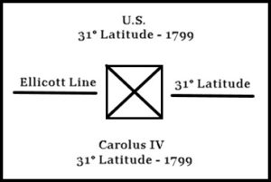
These settlers immediately set up problems of boundary between the Americans in the Mississippi Territory and the Spanish in West Florida. An agreement was finally reached on a boundary between America and Spain (the 31° of latitude) and a surveyor by the name of Andrew Ellicott was agreed upon to establish this boundary line or line of demarcation between the two.
In 1798, Ellicott along with observers from both America and Spain set out for Clarkville on the Mississippi River to begin the survey. Observations indicated that the 31° of latitude was located about 13 miles south of Clarksville on the Mississippi River and near Bayou Tunica. Ellicott would move up navigable streams from the coast until by a series of observations he determined the location of the 31° of latitude. He would then run a guide line both ways and then correct this line to establish the parallel of latitude. These observations or control points were: Bayou Tunica; Alsteris Lake; Little Bayou Soro; Big Bayou Soro; Thompson=s Creek; Pearl or Half-Way River; Mobile River; Conecuh River; Pensacola Bay (trouble with Seminole Indians); Chattahoochie River (escorted by Creek Indians); Flint River; St. Mays River; Point Peter on St. Mays River; and Atlantic Ocean.
During the execution of the line the latitude of St. Stephens was determined to be 31° 33′ 44″. The latitude of Fort Mobile at mouth of the Mobile River as 30° 36′ 30″ and the longitude 5 hours 52 minutes 17 seconds W of Greenwich.
When this Ellicott “Line of Demarcation” was run past the St. Stephens Principal Meridian, a stone was set, known as the “Ellicott Stone”. This stone still stands on Alabama Power Company land near Barry Steam Plant. This stone is marked as follows:
In running the line of demarcation Ellicott usually established a mound or corner at each mile on the final or corrected mile.
Coffee, in 1829, reestablished many of the original Ellicott mounds when he was making the original land surveys of Alabama land just north of the Ellicott or original state line. The lands were patented originally by the Coffee survey. This Coffee and/or Ellicott line ran just north of Lake Jackson at what is now the town of Florida.
The governors of Alabama and Florida decided to move the state line south. In 1853, B. F. Whitner, Jr. made a new state line survey which ran through Lake Jackson at Florala.
As the white demand grew for land in the Mississippi Territory, the U.S. Government set up provisions for the division, designation and sale of the land. The first surveys made in this area were made under special instructions and by special surveyors sent out from Washington, D.C.
In 1797, a surveyor-general was appointed for the lands east of Pearl River. He immediately began surveys in the south central area of the Mississippi Territory. Quite a sizeable settlement had developed by way of land grants from Spain and Britain around St. Stephens on the Alabama River, and also on areas on the Mobile and Pearl Rivers.
Due to the attractiveness of a good water supply a considerable settlement was also developing around Big Spring, later known as Twickingham, and at present known as Huntsville, Alabama.
In 1798, Isaac Briggs was appointed “Surveyor General for Lands South of Tennessee”. He immediately began to lay out the public domain by special instructions, and in accordance with the system devised or approved by the U.S. Congress. Briggs surveyed some around Huntsville and St. Stephens, but principally around Pearl River until 1806.
Seth Pease, Washington, Mississippi was appointed “Surveyor General for Lands South of Tennessee” in 1807, replacing Isaac Briggs. Pease did most of the surveying around St. Stephens, until 1810.
Major Thomas Freeman succeeded Seth Pease as “Surveyor General for Lands South of Tennessee” in 1810. He had surveyed considerably in Tennessee which by 1810 was mostly taken up by permanent settlers. Some Chickasaw land still remained at this time. Major Freeman served for many years in this capacity and surveyed throughout Alabama, although most of his work was probably done around Huntsville and St. Stephens while still the Mississippi Territory. He died in Huntsville, Alabama in 1821.
Between 1812 and 1821, the population increased 81% in what is now Mississippi and 142% in what is now Alabama. During this era General Jackson had waged such effective war against the Indians in the Mississippi Territory that their war strength was effectively destroyed. Treaties were signed with all of the principal tribes of Indians and definite boundary lines were agreed upon. Thus all of the Indians were confined to definite and very restricted areas, this freeing large areas for settlement by whites. After these treaties, there remained only to establish the boundary lines agreed upon, and to survey the land in preparation for sale. Thomas Freeman was Surveyor General of the Mississippi Territory and it was assumed that his duties would extend over the next Indian territories freed.
In view of the big demand for land and the need for quick surveys, General Jackson proposed a plan whereby a new surveyor’s district would be created – thus making an opening for his friend General John Coffee. He pointed out the many benefits to the U.S. Treasury and to the area itself through quick survey and sale.
On March 3, 1817, Congress passed a law providing that a surveyor be appointed for the Mississippi Territory lying North of an East-West line to be drawn from the Mississippi River, through Fort Williams, to the western boundary of Georgia. This line very nearly divided the Territory into half. As drawn this line extended across the present State of Alabama, just north of the City of Tuscaloosa – Fort Williams being just north of the present boundary between Shelby and Bibb Counties.
On March 29, 1817, Coffee was advised by the General Land Office that he had been appointed surveyor of the newly created district (the area north of the proposed line.)
Coffee immediately set out to employ surveyors and survey crews and in May, 1817, began the survey of the designated area. He started his surveys at the northwest corner of Old Madison County. Work was begun by extending the east-west line marking the Southern boundary of Tennessee. At each six mile interval surveyors were turned off to the South to survey townships and subsequently the sections in that particular range.
This was continued until sufficient land to cover fifty townships had been set off. Difficulty was encountered due to unusual magnetic attraction of the needle around Melton Bluff on the Tennessee, and with the survey of islands in the Tennessee River. Coffee suggested leaving these islands to be sold in entirely. The fifty townships were completed on November of 1817.
Since Coffee was instrumental in the original survey of much of Alabama after May of 1817, it would probably be desirable to give a brief biographical sketch of the man.
John Coffee was born in Virginia in 1772; moved to Central North Carolina in 1777, where his father became a wealthy tobacco planter and slave trader. John assisted his father and received a very practical education in farming and business. John also received a thorough formal education, was a good writer, had a good mastery of language, and was an unusually good speller. He became head of the family with considerable responsibility upon the death of his father in 1797 (age 25).
In 1798, John Coffee, with his mother, moved to the new settlement of Nashville, Tennessee, where opportunities in business and trade were greater. Here he began the business of importing salt by boat from Illinois, instead of the previous pack mule method. By 1800, this was a very big business. However, slave trading soon replaced this as Coffee’s main business. In 1802, Coffee went into mercantile business with Andrew Jackson at Clover Bottom. Hard times, after the war, brought on failure of the business, leaving Coffee heavily in debt. These same hard times stimulated interest in new lands bringing the land speculator and the surveyor into more and more importance and prominence.
Through the U.S. Land Act of 1806, disputes between the U.S., North Carolina and Tennessee were settled – leaving Tennessee a strip of land extending through east central part of the state. (The western part of Tennessee had come from a division of the old British providence of Illinois.)
John Coffee turned to these new areas in Tennessee as surveyor, locator and land speculator in 1807. Coffee had influential friends in Washington and through his land activities and political influence began to recover his fortunes through the new land business in Tennessee. He became famous as a surveyor and his services were in great demand. He became one of the largest and most influential land speculators.
One of Coffee’s largest land speculations was in the town property of Huntsville in Old Madison County, which was ceded to the U.S. by the Chickasaw and Cherokee Indians in 1805 and 1806. This territory was not to be thrown open for settlement until 1808, but some land speculators crowded in advance and located claims. The land office for this particular land was located in Nashville, and the land surveys on it were done by Major Thomas Freeman. Coffee surveyed the town site of Huntsville itself, which was known then as Twickingham, and which was later made the county seat of Old Madison County.
Around 1811 to 1813, the British were instrumental in inciting the Indians, especially the Creeks in the Mississippi Territory against the Americans. General Andrew Jackson became very active about this time as a white leader in campaigns against the Indians, and Coffee volunteered as his aide.
Coffee fought effectively against the Indians and became Jackson’s principal aide. He was very active in Jackson’s New Orlean’s campaign, as well as the many campaigns against the Indians. As Brigadier General Coffee was very effective against the Creeks in Southern Alabama, especially in possibly the greatest pioneer conflict with Indians which occurred at Horseshoe Bend in 1814. Coffee was widely honored and praised by the Tennessee legislature for his heroic work finally in routing the British from South Alabama and New Orleans in 1814-15. He was mentioned for decoration by the U.S. Congress.
By this time Coffee’s reputation was widespread. He was appointed on several commissions charged with settling land disputes with Indians; as well as ascertaining and surveying boundary lines fixed by Indian treaties. After the various Indian boundary war run, there remained only the job of surveying the land.
At the insistence of General Andrew Jackson, the U.S. Congress decreed that the Mississippi Territory be divided into two approximately equal parts, and that another surveyor be appointed to assist in surveying and describing the land for quick sale. Coffee was appointed surveyor of the newly formed district in March, 1817. This made Coffee surveyor general only of lands in the northern part of the Mississippi Territory.
On March 3, 1817, Alabama Territory was created from the Mississippi Territory. On April 20, 1818, Coffee’s authority was extended to all public lands in the Alabama Territory. Coffee was reappointed at regular intervals to this position until his death.
In this position Coffee was in complete charge and control of surveying in Alabama.
One of Coffee’s most difficult tasks was the directing of the running of the Alabama-Mississippi state line, which created the Alabama Territory from the Mississippi Territory. By Act of Congress March 3, 1817, the line was extended from the point where the southern boundary of Tennessee intersects the Tennessee River; thence up the same river to the mouth of Bear Creek, thence by direct line to the northwest corner of Washington County (Mississippi Territory), thence due south to the Gulf of Mexico.
Coffee was assisted in running this division line by Major Thomas Freeman, “Surveyor of the U.S. Lands South of the State of Tennessee”.
These two met in St. Stephens in May, 1820, for final arrangements concerning the running of the line, and the location of terminal points. Freeman thought the line should be run with mathematical and astronomical accuracy with a cut out line or rode along the line. Coffee thought this would take too long and decided upon a random compass line which could be carefully corrected to give the required final line. The latter course was finally decided upon.
On April 28, 1821, Coffee appointed James Exum, a Deputy Surveyor with considerable experience in the Pearl River District, to run a guide or random line from the mouth of Bear Creek on the Tennessee River to the northwest corner of Washington County, where the Choctaw trading path crosses.
ALABAMA LAND RECORDS
Isaac Briggs was appointed Surveyor of Lands of the U.S. South of the State of Tennessee in 1798.
Briggs was authorized to survey British grants as well as lands belonging to U.S., in letter of April, 1803. Grantees usually paid surveying costs.
In instructions contained in letter from Albert Gallatin, Secretary of U.S. Treasury, Briggs was authorized to establish the St. Stephens meridian as follows: “From such one of the mile monuments on the southern boundary of the U.S. as you shall think proper you will be pleased to run and survey a north line or meridian, and all the Townships shall be designated by ranges east and west from that meridian, the numbers of each range progressing from the said meridian eastwardly and westwardly, and the number of each township in each range progressing northwardly from the southern boundary line of the U.S.”
Charges were preferred against Briggs by George Davis, a Deputy Surveyor, and others. They were refuted in letter of Briggs to Gallatin in November, 1806.
A letter from Gallatin to Pease in March, 1807 indicates that Seth Pease has replaced Briggs, Correspondence of Gallatin to Pease at this time indicates that Mr. Thomas Freeman is a surveyor in Mississippi Territory under the War Department. Freeman in this letter is asked to survey Indian boundary lines around the Tennessee River. Pease is asked in this letter to employ Freeman.
In this letter to Pease (March, 1807) Gallatin advises that the latitude line forming the southern boundary of Tennessee be run and used as a basis for public lands surveyed below this line. Gallatin suggested that a meridian be drawn through this basis line which would be convenient for laying off ranges to east and west, and townships to south.
In a letter from Pease to Gallatin in June, 1807, Pease states that his deputy surveyors, DeFiance and Fitz, have reported that most of the public lands and private claims in Washington County are nearly completed, and the survey returns made to Pease’s office.
Pease advises Gallatin in June, 1807, that he daily expects the arrival of Thomas Freeman in Natchez and that he will talk with him concerning the Tennessee-Mississippi Territory boundary.
Letters from Pease to Gallatin in June and July of 1807, enclose field notes and plots of T1, 2 & 3, R1W; T1&3, R2&3W; T1, R4W; T5, R1, 2, 3, 4, 5&6W and T6, R3&4 W and T2, R3W. The traverse of the Pascagoula River is not complete. Apparently surveys of Washington County are practically complete and about ready for sale of lands on January 1, 1807.
Deputy surveyors DeFiance and Davis, August 1807, refuse to return results of surveys due to difficulties between them and Briggs.
In a letter from Freeman to Gallatin in August, 1810, Freeman indicates that he has taken over the office of Surveyor of Lands South of Tennessee. Pease was apparently moved or promoted to another position. Freeman received a temporary appointment to this position from Gallatin in September, 1810. He received his permanent appointment by the U. S. Senate on January 22, 1811.
In October of 1810, Freeman recommended to Gallatin the appointment of Alexander Donaldson as District Surveyor for Madison County.
Freeman was advised in June, 1812, of the formation of the General Land Office in Washington, D.C., under the Treasury Department. All returns were to be made to this new agency thereafter.
In March, 1817, Congress passed a law dividing the Mississippi Territory into two almost equal parts. John Coffee was appointed surveyor general of the northern surveying district thus formed and immediately began the survey of fifty townships in the regions between the Tennessee River and the
southern boundary of the State of Tennessee, beginning at the western boundary of Madison County. On the southern side of the Tennessee River fifty townships also were to be laid off.
In 1817 by Act of Congress, the Alabama Territory was created from the Mississippi Territory although it was actually divided from the Mississippi Territory in 1820. Coffee, in April, 1818, was made surveyor general of all public lands in the Alabama Territory. In this position Coffee was in complete charge and control of surveying in Alabama. He was re-appointed at regular intervals as Surveyor General of Alabama until his death in 1833.
Freeman continued as Surveyor General of Lands South of Tennessee, and worked along with Coffee on much of the surveying in Alabama.
Upon Freeman’s death in Huntsville in 1821, Levin Wales was appointed to his position of Surveyor General and served for two years.
George Davis was then Surveyor General for Lands South of Tennessee from 1824 to 1831.
Gideon Fitz succeeded Davis in 1831.
Copies of instructions as to exact methods of surveying the public lands have not been located from Briggs (1798-1806), Pease (1807-1810), Freeman (1810-1821), Coffee (1817-1833), Wales instructions to Gideon Fitz (1831 – ) are available and were as follows:
“Surveyed into Townships 6 miles square by lines run north and south and others crossing them as right angles, and divide the townships into thirty-six square sections, 640 acres each, made of numbering beginning with NO. 1 in the NE corner proceeding west and east alternately. Sections of fractional townships shall be numbered in the same manner. Fractional sections, in the meaning of the law, are not occasioned by the section containing more or less than 640 acres, but by Indian boundaries, District boundaries, State boundaries, navigable water courses, and private claims.”
“Deputy survey shall cause to be marked on a tree near each corner of each section, and within such section, the number of such section, and over it the numbers of the Township, and to note carefully in their respective field books, the names of the corner trees marked, and the numbers so made.”
“That every surveyor shall note in his field book the true situation of all mines, salt lakes, salt springs and mill seats which shall come to his knowledge; all water courses, over which the line he runs shall pass, and also the quality of the land.”
“The Surveyor General shall cause a fair plot to be made of the Townships and fractional Townships, describing the subdivision thereof, and the marks of the corners. The plots shall be recorded in books to be kept for that purpose; a copy thereof shall be kept open at the Surveyor General’s office for public information, and other copies sent to the places of sale, and to the Secretary of the Treasury.”
Act 8, February 11, 1805
“This act provided that the quarter section corners shall be set equidistant from the section corners of the same line. The quarter section corners therefore cannot always be just half a mile from either of the section corners on the same line, but must be governed by the length of the sections lines on which they stand, whether on the N-S or E-W lines.”
Measurements
“The measurements must be made in a horizontal manner as much as possible, by holding up the hind end of the chain over the pin, in going up hills and the fore end in going down hills letting the pins drop from the end of the chain to the ground or by taking the angle of elevation or depression of rising grounds, and make the proper allowance, which would be more correct.”
“The surveyors shall have a spare chain, by which to adjust the other and compare them every morning. If the spare chain cannot be had, then he must have two sticks each 3 feet in length, and measure the chain by stretching it on the smooth ground, a log, or cut down a small tree for this purposed, holding one stick fast which the other is carried forward alternately. The sticks should be square on ends, and use with ease. They must agree with standard measure.”
“As it is desirable that there should not be two corners on the same line, very near to each other, I think it proper to direct the Surveyor, in closing the last mile to the standard parallels, or standard meridians, to run a guide line, and if it intersects near to the mile part, than ten four pole chains, then to close such last mile to said mile part, by a straight line from the last corner set, and make this a general rule in all cases, except some particular reason may render it improper, which will not apply generally.”
Prior to 1818 the land records for the Mississippi Territory were sent to Washington, with a copy being retained in the surveying field office in Pearl River, St. Stephens, or Huntsville.
After 1818, when the Alabama Territory was out from the Mississippi Territory, the land office was in Huntsville under Coffee.
The 1902 Manual for the Survey of Public Lands in U.S. states that when the state of Alabama was admitted to the union in 1819 the “Surveys were practically completed and original records transferred to the Secretary of State Montgomery”.
Coffee built his home in Florence, Alabama. He was away from his home in connection with land surveys and the land office in Huntsville practically the whole time. While away from Huntsville, Coffee left the land office in charge of his chief clerk James H. Weakley. This arrangement was inconvenient and unsatisfactory and so in February, 1823, the survey office was moved to Florence and housed in the offices of the Cypress Lumber Company, which belonged to Coffee.
On December 14, 1827, a fire swept the Cypress Lumber Company destroying all the land office papers.
Many of the land records, however, were not destroyed. Many were in hands of various surveyors, just completed or in process of completion. Copies of most surveys had been sent to Washington, D.C. as the surveys were completed, and so were not destroyed.
A map entitled “A Diagram of the State of Alabama” by W. J. Stone prepared in the surveyor’s office in Florence, Alabama on January 25, 1840, under James H. Weakley shows just what land records in Alabama are available at that date.
All of the original land records were by no means destroyed in the 1827 fire at Florence.
Coffee continued to survey and direct surveys from 1827 until his death in 1833. These records of course were not destroyed. Naturally Coffee was able to recover, retrace, and re-establish many records.
MISCELLANEOUS INFORMATION
Land Surveying
LAND BOUNDARIES:
Monuments:
- Stone, wood, iron, concrete, trees, earth mounds, pits. (Three chops or hacks on marker trees facing a corner usually indicate a corner.)
- Lines: Walls – (Line usually runs in wall; usually center line of wall.)
- Fences – (Posts usually on one side; fence proper on line.)
- Ditches – (Line usually runs with center line of ditch, etc.)
- Line Trees – (Two chops or hacks on side of tree next to line.)
- (A blaze on side of tree next to line.)
- (A blaze Afore and aft@ when line hits tree.)
- (Hopped tree – a tree bent over and made to grow along line.)
- Natural Boundaries – Streams, rivers, lakes, ponds, shores, beaches and trees.
RIPARIAN BOUNDARIES:
A river is navigable in fact: if the tide ebbs and flows therein.
The right bank of a stream is the bank on right when facing downstream.
In general high and low water marks are those established when the water surfaces advance or recede under ordinary stages or conditions.
The thread of a stream is the middle line between shores, regardless of depth of water.
The high-water mark of oceans or tidal waters usually determine the boundary of private lands; the State owns the beach below high-water mark.
COMMON DIFFICULTIES encountered in boundary surveys.
- Inaccuracies, omissions, and inconsistencies in original surveys or records.
- The description in the deed may be inadequate, or may contain errors, or may be inconsistent.
- The description, or part of it, may be based entirely on reference to adjoining land.
- Ambiguity
- Lost or obliterated corners.
- Difficulty of determining the magnetic declination when old records are based upon magnetic bearings.
- Conflicting court decisions or lack of court decisions.
- Reluctance of owners of adjacent land to agree upon the location of a new boundary line.
Note: If, in the resurvey of old boundaries, the surveyor can locate one corner and the direction of one line from that corner, a large portion of these difficulties are overcome. If the corner is marked by a natural or artificial monument, the surveyor is fortunate, provided check measurements made from other points which he believes to be correct prove that the monument is in its original position. Frequently, however, the point of beginning is not marked, but must be found from the deed description. This is often difficult if not impossible, and frequently other evidence must be uncovered. It is necessary to consider so many elements in such a case that often more judgment than skill is required to establish even the beginning point and the direction of the first line.
The surveyor must be governed by legal principles, statutes, and court decisions pertaining to the ownership of land; and these aspects often present much greater difficulties than do the technical aspects of the land surveying itself.
Qualifications of a Surveyor
In most states the law provides that any person who is to do boundary (or Land) surveying in the sense that he is to be in responsible charge of a boundary survey must be registered or licensed by an examining board. Thus, the representative of the state have, in effect, pronounced the surveyor to have the minimum personal and professional qualifications that should permit him to practice. But what degree of care, skill, and judgment may a prospective client properly expect of him? The courts answer this question by quoting the phrases that have long been used in law such as the surveyor “must exercise that degree of care which a skilled engineer of ordinary prudence would have exercised under similar circumstances.” One may desire a more definite criterion, but he will seek in vain. This standard must be used and interpreted in the light of the circumstances of each situation. The question must be resolved if it finally comes to a court by expert testimony of those who profess to know what should be done.
Duties and Liabilities of the Surveyor
The surveyor should make as thorough an examination of all reasonably available sources of information as circumstances seem to permit – and err a little on the side of safety in diligence of search. This advice applies to matters of record, to evidences of boundary or of occupancy to be found on the ground, and to any other items of information which his eyes or ears can discern. He must then pursue his field work and computations by such methods as will secure a degree of precision appropriate to the job and will eliminate the possibility of a mistake.
What happens if the surveyor fails to measure up to the required standard of care and skill? It is generally held that he is answerable in damages to this client for the loss or injury that results from such failure – at least for any loss coming from the use of the land in a manner known to the surveyor to be contemplated at the time of the survey. This responsibility applies to a surveyor who has been registered or licensed as well as to one who has not, and regardless of whether the work is done in an official or a private capacity.
Warning: The knowledge and judgment required in boundary surveying obviously are best acquired from long and varies experience in that particular kind of surveying. A surveyor without that experience should be cautious about undertaking any but the simplest land surveys, not only because he may be held liable for damages resulting from incompetent work, but also because a poor boundary survey is likely to be a public detriment. Too many communities are already cursed with chaotic conditions due to erroneous and inadequate surveys.
Surveyor’s Right of Entry
The survey of a boundary line will almost inevitably require going on other lands than those of the client. Ordinarily, if care is used to cause no appreciable damage, no objection will be raised by the owner or occupant of such land. And if and when such objection is raised, a frank explanation of the surveyor=s need of permission to enter, a sincere promise of due care, and an explanation of the disinterested and non-partisan character of his work will often secure the needed permission. Such entry, however, cannot properly be claimed as a right unless the surveyor is acting in an official capacity or for a legally authorized undertaking; or unless, as in some states, the law provides that surveyors may enter upon land where titles are in dispute for the purpose of running in doubtful or disputed lines and locating or searching for monuments. The invasion should be as brief and unobjectionable as practicable, limited strictly to the purposes of the survey. No reasonably avoidable damage should be done, and any unavoidable damage such, for example, as that due to clearing lines through timber, should be explained, preferably beforehand, and, of course, compensation should be made.
JOHN COFFEE RULES AND REGULATIONS
To be observed by Deputy Surveyors in the Northern District of the Mississippi Territory, in surveying the lands of the United States, which must not be departed from.
All lines of townships and sections must be surveyed by north and south lines run by the true meridian and others crossing them at right angles; — In surveying townships, the survey must begin at the northeast corner, and run south six miles, then west six miles. Then return to the beginning, and run west six miles, and then south six miles to intersect the other line at the extreme corner. In closing the survey of a township, if the lines intersect within 12 poles of the proper point, the survey may be considered correct, except the last mile, which must be resurveyed making the proper variation and noting it to intersect a the proper point. The lines to be marked plainly by a blaze with a chop above and below on all fore and aft trees and near sidelines. Townships to be designated by numbers progressively from north to south, beginning each range with No. 1. The ranges to be distinguished by progressive numbers to the west of the basis meridian. On the township lines at each distance of a mile, between the corners, shall be marked corners for sections different from those of townships. All lines of township will be continued over all rivers without varying in the course or distance. In the corner of each township a tree must be marked with the number of such township, and over it the number of the range, and under it the number of the section, taking the bearing and distance of each tree from the true corner and carefully noting the same with the kind of tree so marked, in the field book.
In the surveying of sections the same rule will be observed as in surveying townships by running two lines, and then returning to the beginning and running the other two, so as to intersect at the extreme corner from the beginning, if the lines intersect within two poles, it may be considered correct, and make the corner of the intersection, noting the excess or deficiency; but if it should be more than two poles, the line so varying must be incorrect, and run over again; in closing the last section with the line of the township, it must be run to the proper station already fixed on that line, in doing which a small variation may become necessary, always noting the same correctly. Section lines will be marked by two chops on fore and aft trees and near sidelines. In each corner of all section a tree must be marked with the number of the section, and over it the number of the township.
And the name of the trees so marked, will be carefully noted in the field book and the distance and bearing of them from the true corner.
Fractional sections binding on navigable rivers or Indian boundaries, will be surveyed by carefully meandering the bank of the river, or running the Indian boundaries, which made such fractions. At all section corners a stake must be set up, with a number of notches at each of the four corners directed to the cardinal points corresponding with the number of miles that it stands from the outlines of the township, the side of the stake will be numbered corresponding with the number of the section it faces.
Quarter-section corners, or half miles stakes, must be set in the center of all sections lines, at equal distance from the corners as near as may be. All sections in each township shall be numbered respectively, beginning with No. 1 in the northeast section, and proceeding west and east alternately, through the township, with progressive numbers until the thirty-sixth shall be completed.
The southern boundary of the State of Tennessee, and the meridian of Madison County will be the base and meridian of all surveys made in this district. The lines of the townships and sections of Madison County will be extended to the south and west, so as to perfect all fractions occasioned by the diagonal line theretofore existing between the county and the Chickasaw Indians.
All lines must be run horizontally, by leveling the chain and plumbing the pins where the ground is uneven, and measured with two pole chains subdivided into fifty equal links. Each Deputy Surveyor will adjust his compass and chain, to the standard kept in the surveyor=s office for that purpose. Every surveyor shall carefully note in his field book the true situation of all mines, salt-licks, salt-springs, and all mill seats, which shall come to this knowledge; all water courses, over which the line he runs shall pass, with the bearings of the same; and also the timber and undergrowth, whether mountainous, hilly, or level; and the quality of the soil, whether first, second or third rate. These field books shall be returned to the principal surveyor of the district, with such other information relating to the situation
and quality of the lands, as the Deputy may be processed of. All Deputy Surveyors will make return of their surveys, agreeable to foregoing instructions, at such time as the principal surveyor of the district may require.
The Surveyors will administer an oath to their Chainmen Markers, faithfully to perform their duties as such, and not to depart their service until the expiration of the term for which they have engaged.
4th May 1817 /s/ John Coffee
FREEMAN SURVEY OF THE INITIAL POINT HUNTSVILLE MERIDIAN
In a letter dated July 14, 1807, to the secretary of the Treasury, Seth Pease surveyor south of Tennessee states: “Mr. Thomas Freeman is on his way from this place (Washington M.T.) to the Tennessee River, in order to run the boundary lines of the Chickasaw cession, he has agreed to take the latitude, and run the dividing line between this territory and the State of Tennessee so far as relates to said session, also to run the basis meridian.”
In a November 5, 1807, from Pease to the Secretary of the Treasury the following reference is made to the Freeman survey in northern Alabama. “The tract which Freeman is now surveying near the Tennessee River is a triangle, whose vertex is at the Tennessee River and having a basis of about twenty fives miles on the south line of the State of Tennessee and its sides about forty miles B to survey this into sections will require about 4000 dollars.”
In a letter dated August 2, 1809, Seth Pease imparts the following information relative to the Freeman survey to the Secretary of the Treasury: “I mentioned in my instructions to Mr. Thomas Freeman that the law required a post be set at each half mile for the corners of sections, or rather that it be placed just half way on each line between the corner of sections as run.
Mr. Freeman has not mentioned in his field notes that the setting of the half mile post; but I do not conclude that he has omitted doing it, for it has been the practice of some surveyors, to omit noting in their field book, setting up the monuments, such as mile or half mile post. Conceiving that this was understood to be done regularly notwithstanding. I will enquire into this matter.”
In a letter dated October 25, 1809, Pease Informs Gallatin that: “Mr. Thomas Freeman informs me that he has set half mile post on all his lines in his survey of Madison County, but that they will not always be found exactly half way between the section corners. I can furnish the Deputy Surveyor for that District with instructions for placing any one correctly which may not be so, without giving him an extraordinary trouble.”